
Slovakian High Tatras (Tatry Słowackie Wysokie)
compact map
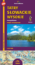
scale
legend
size
1st edition
author
publishers
ISBN
1:27 500
3 languages
100 x 78 cm
2007
Michael Siwicki
978-83-7499-093-6
distribution
![]()
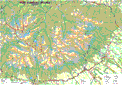
A map of High Tatras (with Bielskie Tatras) in 1:27 500 has pocket size and clear image. The legend consists of 80 signs in 3 languages. You will find time distances on the routes, grid for GPS, vivid hill shading and others.
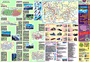
On back side there is big guide with plenty of informations. There are few words about the shelters, photos and sketches of the birds.