
Tatra National Park (Tatrzański Park Narodowy)
Podhale from Witów to Bukowina Tatrzańska
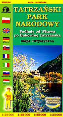
scale
legend
size
1st edition
author
publishers
ISBN
1:25 000
8 languages
119 x 81 cm
1998
Michael Siwicki
83-87873-05-5
distribution
![]()
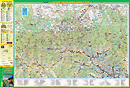
A map of Tatra National Park in 1:25 000 scale is our main product. It has come to be very popular from the first edition, among distributors, specialists and users. It is the most detailed map of Polish Tatras, which could be drawn on one sheet of paper in such great scale.
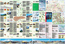
The explanation contains large number of 105 signs, described in 8 languages (PL, GB, D, RUS, SK, F, I, H). Thousands of names and symbols guarantee giving complete information. Vivid hill shading and rocks clearly show relief. There is geographical grid for GPS here, pictures of animals and plants, time distances etc.
Directory on back side is uniqual. Besides geographical informations about the mountains, you can find notes about mountain huts with photos and places for commemorative stamps. There is city-map of Zakopane here, schema of touristic routes, coverage of mobile phones map, touristic directory, panoramas, several photos of landscapes, pictures of animals and plants as well as silhouettes of birds in flight.
The map is up-dated every year, and the legend is systematically growing up.